Southern California Backcountry Discovery Route

Map not loading? Visit our Main Interactive Map. For best performance and experience, use the latest web browser version of Microsoft Edge or Firefox. We are currently troubleshooting technical issues with Chrome.

The long awaited Southern-California BDR (CABDR-South) is the ninth route developed by the BDR organization for dual-sport and adventure motorcycle travel.

Take a spectacular, yet challenging 840-mile ride across the south-eastern region of California. Rugged two-track and remote dirt roads lead riders through majestic canyons, rocky riverbeds, and sandy washes of California’s famous deserts and national preserves, including a dream ride in the Mojave Preserve and Death Valley National Park. This is the first BDR designed for winter-season riding.

The Butler Motorcycle Map and the film dvd are now available for sale in the BDR Store HERE

In the links on the right, you will also find an interactive map with section descriptions and the FAQ for the route.

CABDR-South – SECTION DESCRIPTIONS

Section 1: Yuma, AZ to Blythe, CA – 120 Miles

The CABDR-S starts in Yuma, AZ along the Colorado River. Make sure you schedule a little extra time to visit the Territorial Prison State Historic Park and Museum, and old downtown has some great places to eat and stay. 

The route heads north and can be very sandy near Picacho State Rec Area.  There is an optional bypass available which remains on pavement to skip this are if you’re not up for sand right out the gate.  Continuing on, beautiful primitive dirt roads take you north, including a portion of the Bradshaw Trail and into Blythe.

Section 2: Blythe, CA to Desert Oasis, CA – 122 miles

Traveling north from Blythe you will parallel the Colorado River which is the border of California and Arizona. Shortly after, you will leave the pavement and hit dirt at the fascinating Blythe Intaglios which were discovered in 1931. These giant pieces of art are similar to the Nazca Lines in Peru and the shapes are believed to have been formed prior to 900 AD.  There is an optional Harder section hear that takes you into a short, but technical remote portion of the California desert.  All riders can still stop and explore the intaglios just off the highway and not take the optional advanced section.

Traveling west, the route nestles at the foot of the Big Maria Mountain Wilderness before turning back toward the Colorado River. Once again, the route will take you on a two-track road that ribbons its way between two wilderness areas, so please make sure to stay on the road. 

After traveling through this desolate area, you will hop onto Highway 62 where you will see structures of times long since past and the Shoe Tree “gas station” before getting onto Cadiz Road. Cadiz Road will connect you to the “Mother Road” or better known as Historic Route 66. Route 66 travels 2,448 miles from Chicago to Santa Monica and is a destination for motorcycle riders from all over the world.

The end of this section is unique and is the only final point in the entire BDR system that ends at a gas station, or should we say a “Desert Oasis”. However, this isn’t your typical gas station . . . you’ll just have to see it to believe it. Be warned, the gas isn’t cheap.

Section 3: Desert Oasis, CA to Primm, NV – 94.4 Miles

Section 3 will take you out of the low desert and into the Mojave National Preserve. When entering the Mojave you will see the Goffs Schoolhouse and Cultural Center. This unique place at one point housed 16,000 troops during WWII and has preserved old railroad and mining artifacts for you to visit.

Further on, you will enter the Granite Mountains. These granitic rocks have eroded into unusual rounded shapes that include spires, perched boulders and curved cliff faces.

The rocks in this area represent the roots of ancient continental-margin volcanic systems. Most are late Mesozoic in age (80 to 180 million years old) and were formed at a depth comparable to the Andes Mountain chain in South America.

Some of the sites along the route include the Government Holes, which were wells dug so people traveling across the Mojave would have access to water. The Death Valley Mine, Evening Star Mine and WWI Memorial will all be places you’ll want to stop and explore.

Riding the two tracks in the midst of the Joshua Trees will keep you on your toes and is an experience you can only get in the Mojave Desert. This section ends in the small gambling town of Primm, Nevada, which is also one of the stops for the NVBDR. 

Section 3: Desert Oasis, CA to Primm, NV – 75.9 Miles

Fueled and full of supplies, you leave Primm and pass through the middle of the Ivanpah Solar Electric Generating System. This monstrosity is a 377 megawatt solar complex using mirrors to focus the power of the sun atop power towers. The first big technical climb comes just after Ivanpah up to the Colosseum Mine. This rocky steep climb has gradually gotten less technical over the years but is still a challenging section.Travel along the Powerline Road to Excelsior Mine Road, which leads you into the Kingston Range. You can find several BLM camping areas along the road.

Take the optional track for Mesquite Valley for yet another advanced option.  Nearing Tecopa, don’t miss the opportunity to stop at the China Ranch for one of their famous date shakes. The small town of Tecopa is the home to many unique hot springs to stay at, and the small bbq brew pub is the first real food destination on the route and should be on your itinerary.

Food, fuel and some lodging can be found in the town of Shoshone with more options in nearby Pahrump, NV.

Section 5: Shoshone, CA to Beatty, NV – 141 Miles

The Ibex dunes will be your first taste of Death Valley. You will find a short stretch of dune-type sand to get your heart racing. Harry Wade Road will take you to the heart of Death Valley where you will travel the Westside Road. You can take a few detours and ride the Artists Palette Loop and Badwater Basin, the 8th lowest elevation on earth. 

Passing by the Devil’s Golf Course will remind you that you’re not in Kansas anymore. Furnace Creek and Stovepipe Wells offer camping, lodging, food and fuel. If you plan to stay here, reservations ahead of time are suggested.


From here, take the optional Advanced track over Chloride Cliffs or remain on pavement to Beatty, NV.

Section 6: Beatty, NV to Lone Pine, CA- 153 Miles

Still deep in the heart of Death Valley there is plenty to explore off-route and we suggest you do. There is so much this area has to offer in the way of good adventure. The route takes you into Titus Canyon, which is a deep limestone-walled slot canyon and a must see. This road travels in a one-way direction past the ghost town of Leadfield, which boomed for less than a year in 1926. Before heading down into Titus Canyon, you must go into Beatty, NV and purchase fuel and any rations for the trip to the Racetrack and beyond. There are no services between Beatty and Lone Pine along the route.

The Ubehebe Crater is a stop not to be missed before the final 20 miles to the Racetrack. Ubehebe Crater is a large volcanic crater 600 feet deep and half a mile across that exploded possibly as recently as 300 years ago.

When traveling the Racetrack road you will come to the famous Teakettle Junction. Just look for the sign covered in dozens of dangling kettles. People leave the kettles there as a kind of tribute, inscribing them with messages and hanging them all over the sign in a kind of ritualistic acknowledgment of the people willing to brave the desolate desert landscape.

At the junction you can decide to travel six more miles down to the Racetrack, then backtrack on the main route over Hunter Mtn. If you haven’t seen the Racetrack, the six mile trip is worth it just to see the ‘moving’ rocks on the Playa.

The optional advanced section of the route takes you down Lippincott Pass. Lippincott is for those who are not faint of heart. This steep, rocky and off-camber descent will get your attention and the views down into the Saline Valley floor are incredible.

At the junction of Saline Valley Road and White Mountain Talc Road the main route will continue as an advanced route only up to Cerro Gordo Mine. This road is a steady climb through a deep rock wash and finally a smooth two-track up 8,000 ft. There is an alternate route to this climb by going to Highway 190 and around to where the route comes down to Cerro Gordo. The climb from Highway 190 up to is worth it just to see the moving rocks on the Playa. Cerro Gordo Mine is easy and worth the effort to get there.

Lone Pine is a great destination for a motel if you haven’t had a good shower in a few days. If camping is your gig, then make sure you stay in the Alabama Hills for a night.

Section 7: Lone Pine, CA to Benton, CA- 133 Miles

Traveling from Lone Pine out through the Alabama Hills is one of the highlights of the CABDR. These unique rock formations were chosen for the set of many old western movies. If you have time before leaving Lone Pine, stop into the Western Movie Museum and learn all about the movies filmed in the area.

Manzanar National Historic Site is the next stop on the route. In 1942, the United States government ordered more than 110,000 men, women and children to leave their homes and detained them in remote, military-style camps. Manzanar War Relocation Center was one of ten camps where Japanese- American citizens and resident Japanese aliens were incarcerated during World War II. If you have the time, this is a well done museum and one not to miss.

Traveling through the Owens Valley floor, just off the route is the Reward Mine. The trail leading to the Reward Mine is steep and rocky with embedded boulders. You can ride into the mine for more than a quarter mile but do so at your own risk. There are several places to turn around. You may want to make sure your flashlight works just in case the bike stops.

The route splits at the mouth of Mazourka Canyon. The main route remains on the valley floor crisscrossing the valley and the foothills up to Bishop. The ALT Harder route takes you up Mazourka Canyon where you top off on Papoose Flats. There is a short descent into Wyman Canyon where you cross a creek several times to a lookout of the entire valley.

The Silver Canyon descent will test your steep downhill skills… make sure you take it easy and don’t cook your brakes before stopping in Bishop, another great town to stay in.

The final stretch of the CABDR is an easy road passing by a massive collection of Petroglyphs at the Fish Slough site. About 8,000 years ago this region was settled by the ancestors of the Bishop Paiute-Shoshone tribe. Take time to get off the bike and check out the collections, you will find hundreds hidden throughout the rocks.

Out of nowhere, Chidago Canyon appears and gives you a final taste of a slot canyon before coming to the final stretch. Plan to stay at the historic Benton Hot Springs. You may stay at the small B&B or at the campground where you have your own private hot springs pool camp-side. Reservations are a must for both. Food and fuel can be found in Benton, which is one of the oldest existing towns in Mono County and was originally used by Native Americans for the use of the hot springs.

Photos by Ely Woody.

Plan Your Adventure

Planning your adventure is half of the fun. We’ve gathered some useful information for this route in the below sections. Be sure to check out the lodging, food and fuel locations. You may find that there are more options than we have listed, but these are key places you may find useful. You may also find the packing lists, discovery points and FAQ’s helpful for developing your plan.

The Butler Motorcycle Map for this route is also a great tool to have in the planning and riding of the route. They can be purchased for a small fee at the BDR Store.

CABDR-SOUTH LODGING

South of Oceanside, head east to the historic mining town of Julian for a break off the bike and enjoy some of the best apple pie in the state.  A quaint Main St. and B&B’s if you need to spend the night.

Visit Website »

In 1985, the Bureau of Land Management drilled a new well 965 feet (294 m) in depth to support the new Wiley’s Well Campground, one of only two developed campgrounds in the Mule Mountains Long-Term Visitor Area. The water is both hot at 90 °F/32 °C and heavily mineralized; it is pumped into a cistern to help cool it to a temperature suitable for drinking.

Visit Website »

Half way through this BDR and you may be ready for rustic lodging or a soak in a hot spring, particularly if you are riding in the middle of winter. Tecopa Brewing Company is just down the road too.

Visit Website »

Spicer Ranch boasts sprawling green pastures with lush green grass and several freshwater pools, which provide habitat for a handful of endemic creatures found here, and only here, like the Amargosa Toad. In addition to the hiking and mountain biking trails system found throughout the property Spicer Ranch invites anyone visiting to spend the night at the on-site, donation-based campground, complete with shady campsites, picnic tables, hot showers, and restrooms.

Visit Website »

Reward your accomplishment for completing the CABDR-South with a stay at this Historic Bed and Breakfast.  Soak in the natural fed hot springs tubs, have a wonderful breakfast after a night spend in a bed rather than sand and rocks from the previous evenings.  Or, camp out behind the Inn. Even the campsites have their own private tubs. Reservations recommended.

Visit Website »

CABDR-SOUTH FOOD

South of Oceanside, head east to the historic mining town of Julian for a break off the bike and enjoy some of the best apple pie in the state.  A quaint Main St. and B&B’s if you need to spend the night.

Visit Website »

Aha Quin Resort or Water Wheel Resort ( 29630 US-95 just up the road from Aha Quin). Not much more there than mobile home parks situated on the banks of the Colorado River, but if you didn’t get supplies in Blythe, the general store is your last opportunity for a while.

Not so much of a desert Oasis as it is a place for food and fuel. Gas will probably be the most expensive on this route but grin, bare it, and be thankful you are not filling up a Winnebago, as there’s not another option.

Address: 31251 Goffs Rd, Essex, CA 92332

Phone: (760) 694-0181

Date Shakes! You have earned it, don’t pass up chance to hydrate and carbo load before entering Death Valley. Dates are 75% Carbohydrates, 21% water and the perfect desert snack. Savoring all the varietals here will leave you feeling like King Tut.

Address: China Ranch Rd, Tecopa, CA 92389

Phone: (760) 852-4415

Visit Website »

CABDR-SOUTH FUEL

South of Oceanside, head east to the historic mining town of Julian for a break off the bike and enjoy some of the best apple pie in the state.  A quaint Main St. and B&B’s if you need to spend the night.

Visit Website »

Not so much of a desert Oasis as it is a place for food and fuel. Gas will probably be the most expensive on this route but grin, bare it, and be thankful you are not filling up a Winnebago, as there’s not another option.

CABDR-SOUTH MOTORCYCLE DEALERSHIPS

LONG BEACH BMW

Long Beach, CA

WEBSITE

The #1 selling BMW Motorrad dealer in the USA 9 out of the last 10 years, Long Beach BMW Motorcycles is home to a large inventory of new and used motorcycles and experienced service team of BMW Master Techs.

We also have a large inventory of BMW rider gear and accessories for your ride. Whether you are shopping for a bike, coming in for parts or service, or just passing through the area, all riders are welcome to stop by for a cup of coffee or to relax in the rider lounge. Conveniently located off the 405 freeway and adjacent to the Long Beach Airport.

CABDR-SOUTH DISCOVERY POINTS

Established 1776.  This is the gem of the California Missions, located less than a mile off the 5 Freeway, it offers a glimpse back in time to what was happening on the “Left Coast” at the same time our Nation was being founded.  If you can’t make it this trip, you will be back, just as the Swallows of lore.

Visit Website »

South of Oceanside, head east to the historic mining town of Julian for a break off the bike and enjoy some of the best apple pie in the state.  A quaint Main St. and B&B’s if you need to spend the night.

Visit Website »

Ok, you could spend days riding amazing dirt roads or just stop here for a scenic overlook on your way, the Carrizo Badlands Overlook.

Visit Website »

So, you want to brush up on your sand skills before riding the CABDR, or make like Ricky Brabec or Andrew Short and get skills for the Dakar?  Well this is the place and it’s right on the way.

And check out what’s left of the “Wood Planked Road”, early road builders’ efforts to tame the drifting desert sand.
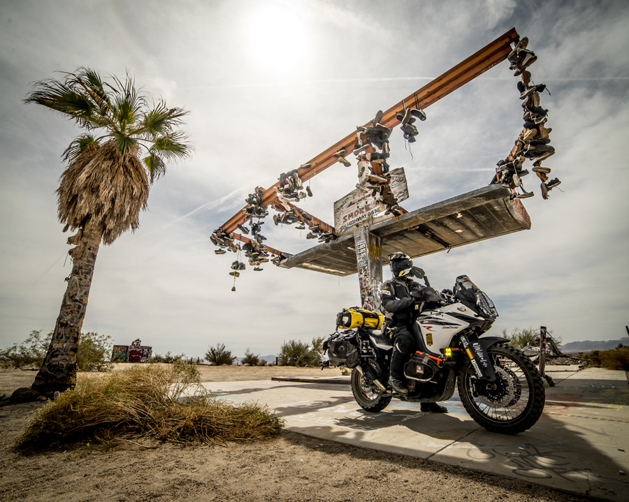
Visit Website »

Could be, but then again since the world is a sphere, just about any place could warrant this claim. If you are into funky, interesting places, this is worth the time.

Visit Website »

Make the stop, even if it’s not 3:10.  You will be rewarded with a peek into the life of interesting desperados, living out their days in sweltering summer heat or freezing winter nights with nothing but steel bars to quell the elements.

Visit Website »

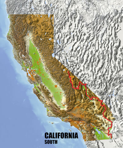
Finally! You are on the route and it begins with a jaunt over the one lane Ocean to Ocean Bridge that separates Yuma from Winterhaven, CA. and the start of the CABDR-South.
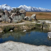
Visit Website »

If you choose to camp after traveling south to Yuma, this historic state park is just up the road and well worth the fee to camp.
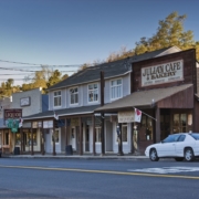
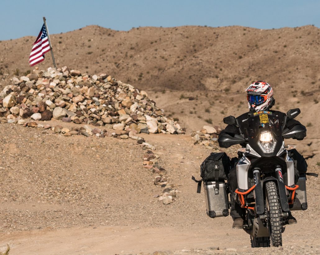
Visit Website »

Created in 1862 this was the first trail that crossed the Riverside County desert all the way to the Colorado River to allow gold seekers to get to La Paz AZ.  There is camping (Wiley’s Well 33°29’36.8″N 114°53’20.8″W  or 33.49356 , -114.8891 ) just north of where we pick up the Trail heading east, but no potable water.

Visit Website »

Not to be missed.  Step back in time, way back in time. Experience Native American ground art believed to be over 800 years old and similar to the famed Nazca Lines found in Peru, although on a smaller scale.

Visit Website »

Aha Quin Resort or Water Wheel Resort ( 29630 US-95 just up the road from Aha Quin). Not much more there than mobile home parks situated on the banks of the Colorado River, but if you didn’t get supplies in Blythe, the general store is your last opportunity for a while.

Established on November 11, 1926, the highway, which became one of the most famous roads in the United States, originally ran from Chicago to Santa Monica covering a total of 2,448 miles. Get your kicks here;  oh wait, we all have electric starts now.

Not so much of a desert Oasis as it is a place for food and fuel. Gas will probably be the most expensive on this route but grin, bare it, and be thankful you are not filling up a Winnebago, as there’s not another option.

A lot here in the middle of nowhere.  If you have time check out the Museum before entering the Mojave Preserve.  You could spend a week just riding the Preserve alone, exploring everything from Afton Canyon to ZZYZX.   Now’s the time to extend the vacation, if you have cell coverage.

Visit Website »

After WWI, returning veterans who had been exposed to poison gas found the deserts of California provided health benefits.  This cabin constructed in 1929 is an example of the homesteads build primarily of native materials.

Visit Website »

A glance down and right will reward you with a view of the original wagon wheel tracks of the infamous Mojave Road.  This trail once connected Fort Mojave to Camp Cady and previously used by the Chumash as a trade route due to the existence of what little water is to be found in the Mojave.

Death Valley Mine (though not in Death Valley) is an example of mines found throughout California.  Established in 1906 as a mine and a community for miners from surrounding claims.

As the only tin ore mine in the Mojave, it was also one of the few with a crusher on top of the head frame.  As this mine ceased operation in 1944 it is still relatively well preserved.

Visit Website »

A medic and an explosives trainer (kinda makes sense) during WWI, this camp is yet another example of a harsh life carved out of the Mojave Desert.  Be thankful you have heating, air conditioning and a flush toilet awaiting the return to your homestead.

Producing an amazing 377 megawatts of energy, but not nearly the 1.21 gigawatts needed for your Flux Capacitor to get you back to the Future.   Oh well, plenty of history yet to be explored on the CABDR-South.

Visit Website »

Everything you could ever want to know about this big hole in the ground, right here.  Ride down to the bottom at your own risk if you must, but resist the urge to take a dip in the multi-colored waters of the lake.  Word on the trail is that the residual chemicals left over from mining operations would leave your skin looking like something from the Apocalypse.

Visit Website »

Date Shakes! You have earned it, don’t pass up chance to hydrate and carbo load before entering Death Valley. Dates are 75% Carbohydrates, 21% water and the perfect desert snack. Savoring all the varietals here will leave you feeling like King Tut.

Visit Website »

Half way through this BDR and you may be ready for rustic lodging or a soak in a hot spring, particularly if you are riding in the middle of winter. Tecopa Brewing Company is just down the road too.

Visit Website »

Trying to find a quick way through Death Valley to the Gold of California almost proved disastrous for the wagon train guided by Harry.  Fortunately, he found a southern exit from Death Valley before they ran out of water. We use this route as our Southern Entrance to this place of storied heat and wonder.

No, your GPS has not gone on the fritz.  You are now well below sea level. In fact, at 282 Feet below Sea level Badwater Basin (36°13’47.3″N 116°46’01.2″W or 36.22981, -116.767) is not just the lowest point in the US, but the 8th lowest elevation on earth.

This canyon offers up sweeping views, steep canyon walls, remnants of a boom town that lasted less than a year (Leadville) and represents classic Death Valley Adventure riding.

Damaged in a massive flashflood that roared through Death Valley in Oct. 2015 restoration is not yet complete, but when it is, it’s not to be missed.

Visit Website »

Your friends will think you had one too many when you tell of your visit to Ubehebe. Pronunciation aside, this massive crater is just one of the amazing things Death Valley offers on this route.

Visit Website »

An amazing set of atmospheric events combine to make rocks mysteriously slide across this desert playa leaving tracks etched in mud.   For decades this mystery went unsolved, many believing they were moved by the hand of God.

Visit Website »

Here’s your chance to experience a living, breathing ghost and mining town.  Step inside the American Hotel, built in 1867, saunter up to the bar or sit at the poker table in the parlor where many a game ended in a gun fight (bullet holes still visible in the walls).

Visit Website »

If you are a fan of Western films, hitch your Adventure bike to a post out front and learn about the hundreds of films shot in and around Lone Pine California.  Make sure you pick up a map of the Alabama Hills with GPS coordinates to place yourself and your bike in your favorite film, from movies shot before sound, to recent blockbusters.

Visit Website »

After the Japanese attack on Pearl Harbor, President Franklin D. Roosevelt signed Executive Order 9066 authorizing the establishment of camps like Manzanar to intern American citizens just by virtue of their ancestry. This affront to the liberty we all hold dear has been thoughtfully preserved to give each visitor insight into the lives of those interned and reminds us how our government, complicit with Americans overcome with unfounded fear, responded with barbed wire and armed guards.

Visit Website »

Not for you if you suffer Nyctophobia or Claustrophobia but the rest of us will enjoy the opportunity to ride our Adventure bikes deep into depths of a Gold and Silver mine. Just have a flashlight handy if you decide to experience total darkness by shutting off your bike and can’t find your ignition key.

Just North of Bishop and right on the route is a Railroad Museum that resembles the Main Street of any western town we have envisioned since our youth.  Rekindle that youth with a stop here before continuing the last leg of the CABDR-South.

Visit Website »

Around 8,000 years ago this region was settled by the ancestors of the Bishop Paiute – Shoshone tribe. Over the course of thousands of years these earliest settlers left messages carved and painted on the three-quarter of a million-year-old volcanic rock across the region. Much of the messages carved in stone are unknown, however there is some consensus that they could be of celestial recordings or ceremonial in nature as opposed to many petroglyphs found in the West that record animals, hunters and tools of daily life.

Reward your accomplishment for completing the CABDR-South with a stay at this Historic Bed and Breakfast.  Soak in the natural fed hot springs tubs, have a wonderful breakfast after a night spend in a bed rather than sand and rocks from the previous evenings.  Or, camp out behind the Inn. Even the campsites have their own private tubs. Reservations recommended.

Visit Website »

CABDR-SOUTH PACKING LIST

This packing list serves as an example and is not intended to be a complete list for your backcountry riding needs. Feel free to customize this list to work for you.

  • Helmet
  • Boots
  • Goggles
  • Gloves (2 sets)
  • Protective gear (pressure suit, Leatt brace, knee braces)
  • Jacket
  • Pants
  • Balaclava or neck gaitor
  • Water bladder or bottle
  • Hydration pack
  • Ear plugs

FREQUENTLY ASKED QUESTIONS

Below are answers to some of the Frequently Asked Questions about the Southern California Backcountry Discovery Route.

The Southern-California BDR (CABDR-South) is the ninth route developed by the BDR organization for dual-sport and adventure motorcycle travel. This spectacular, yet challenging 840-mile ride across the south-eastern region of California consists of rugged two-track and remote dirt roads that lead riders through majestic canyons, rocky riverbeds, and sandy washes of California’s famous deserts and national preserves, including a dream ride in the Mojave Preserve. This is the first Wintertime BDR.

Most years you should be able to ride starting mid-October until mid-April.  This is a wintertime route, so winter storms may hamper some times and high elevations may see some snow. You must check weather forecasts and check local conditions before heading out.

The CABDR route is designed to be ridden on adventure and dual-sport motorcycles. There are no single-track style trails on this route. You can expect to cover sections of road with deep ruts, loose rocks, deep sand, rocky hill climbs/descents and other challenges.  Road conditions change from week to week based on the recent weather.  Depending on time of year and weather, there may be a few small deep water crossings. Flash floods can cause significant damage to roads.  Don’t cross flooded washes. Wait until water subsides. Overall, the CABDR-South is one of the harder BDR routes, and is suited for riders with intermediate and above off-road skills.

The California region can have strong thunder storms during the springs months.  These storms can contain lightning and heavy downpours which can result in flash floods.  Fast moving snowstorms can also come up quick and leave you stranded, so always keep an eye to the sky.  You may also encounter high winds and sand storms on this route.

Yes the route can be done North to South. Lippicott Pass will be more of a challenge going North to South as you will be riding uphill.

You will need to have a National Parks Pass or purchase a pass when entering Death Valley.  There are kiosks at several of the entrances (but not on the route) so, purchase them in Furnace Creek at the Rangers Office. You do not need a pass for the Mojave Preserve.

The National Park system does require groups of 7 vehicles or more traveling together to obtain a permit.  Visit this site for more information – https://www.nps.gov/moja/planyourvisit/permitsandreservations.htm

Most people average 150 miles a day on a backcountry motorcycle trip. Plan on doing this route in 6-7 days depending on how fast you want to travel and how early you want to roll out of camp. There is a lot of history to see and places to visit on the CABDR so planning a little extra time is suggested.

The longest section without gas is 153 miles (Section 6 from Beatty, NV to Lone Pine).  Carrying extra gas is strongly suggested. Never pass up the opportunity to get gas. This section has very little travel, so hoping someone will come by with gas might be just that… a wish.

There are  a few campgrounds along the route. The Butler Motorcycle Map for the CABDR has a tent icon showing campgrounds on the route and many near the route.  There is dispersed camping along the way. Visit the National Parks websites to find out about camping in the Mojave National Preserve and Death Valley. https://www.nps.gov/moja/planyourvisit/camping.htm , https://www.nps.gov/deva/planyourvisit/camping.htm.

Established camping is available in:

Yuma, AZ
Blythe
Off Route: Needles
Primm, NV
Tecopa
Shoshone
Furnace Creek
Lone Pine
Big Pine
Bishop
Benton Hot Springs

In most cases camp fires are allowed, but check with local Ranger Stations to determine if campfires are allowed before you build one. In most cases, campfires are only allowed in fire rings. Be sure to fully extinguish fires so they are DEAD-OUT. Use water to ensure a fire is fully extinguished and the ground is left cool and wet.

The answer is no. The CABDR has some motel opportunities on the route and if you travel off route you will fine more motels in the bigger cities . If you do decide to camp, you will find official campgrounds on the front of this map with a small tent icon and some primitive backcountry camps can be found along the way. Because of the limited beds available in the small towns along the CABDR, it is recommended that riders make reservations ahead of their arrival.

DANGER -There really no water sources along the route other than, you can find potable water in the towns along the way.  It is suggested you carry twice as much water as you think you need. You can get extremely sick or die in the desert without water.  Here is a video on water filtration filmed in the Backcountry: http://youtu.be/vqOFZAoZdTU

Always bring a complete set of maps for the area you plan to ride. They have good information about roads, water sources, and are an indispensable resource when the GPS doesn’t work, or is giving questionable advice. Unplanned events can occur and having paper/synthetic maps of the area can be a life saver. National Forest maps are available at http://www.fs.fed.us/recreation/map/state_list.shtml#U and local Ranger Stations. CABDR Butler Motorcycle Maps are available at www.touratech-usa.com or www.butlermaps.com.

The tracks for the route can be downloaded free of charge online at https://ridebdr.com/download-tracks/.

Any GPS unit capable of handling 15 track logs with a minimum of 1500 points each is suitable for use on the CABDR. Garmin models that work best for this application are: Zumo 590/595/395/396, Montana, and 276Cx. Many other GPS units are compatible with the GPX file format, check the owner’s manual of your device for more information.

Any bike that has a license plate, can run knobby tires, is set-up to carry the gear you plan to bring, and has the fuel range to make the distance between gas stops. Most adventure or dual-sport motorcycles will be suitable for the trip.  Choose the bike that you are the most comfortable riding off-road.

DOT approved knobby tires are strongly recommended.

Segments of this route can be ridden two-up if you are skilled in riding off-road two-up. But we do not recommend it be ridden two up.

There are a few gates along the route. Please leave the gate as you find it.

We do our best to post the most up-to-date information on our Route Updates Page. We depend on the BDR community to inform us about route and road conditions, so if you encounter any road closures or severe conditions that are worth reporting, please contact us with the information.

There is also a dedicated CABDR-S Facebook Group Page. We recommend that you join the group prior to your trip to read trip reports and comments from other riders about their experience on the route.

Don’t forget to use our Interactive Map to get route conditions in real time. Read this Article to a quick tutorial on how to use the Interactive Map.

To find out information about Death Valley Road closures visit this LINK.

Much of this route is remote and out of reach for cell phone towers. There will be long sections with no coverage. Your best bet is to talk or text in the towns or on top of mountains. You will be surprised where you get coverage and where you don’t. A satellite communication device is a good idea in the backcountry.

The CABDR is a habitat to Deer, Mountain Lions, Badgers and Coyotes. Safe food practices while camping are an absolute for your safety and the animals safety. Rattlesnakes are also found throughout the route.

Rating the Routes by Difficulty

We often get requests to provide the difficulty ratings of the BDR. We do not officially rate roads or routes because the difficulty can change from day to day depending on weather, changes in road conditions, and road damage caused by a variety of forces including wind, storms, flooding, snow, logging, forest fires and more.

The difficulty experienced by an individual also depends on their off-road skills, level of fitness, stamina, bike size and amount of weight carried on the bike. For these reasons we can’t provide a rating system like a ski resort or OHV park.

We can help you a bit by ranking the existing Backcountry Discovery Routes from most difficult to least difficult. Here is the list: CABDR-South, NEBDR, AZBDR, ORBDR, WYBDR, UTBDR, COBDR, NVBDR, WABDR, NMBDR, IDBDR, MABDR.

So CABDR-South is the most difficult especially if you ride the expert sections and MABDR is the easiest in general terms. Although MABDR is the easiest there are still a few challenging rocky sections and the several water crossings that can get very difficult if the water is high.

Be sure to also review the FAQ’s for each route and our General FAQs prior to embarking on your trip.

Backcountry Discovery Routes is a 501c(3) non-profit corporation. © 2022 - 2024 Backcountry Discovery Routes, Inc. All rights reserved. Terms of Use.