Beachcomber Motel
Perched above the Pacific with sweeping ocean views, the Beachcomber Motel offers a classic Fort Bragg stay with front row sunsets and fresh coastal air. It is the perfect home base for travelers seeking easy beach access, walkable dining, and a relaxed seaside vibe. BDR riders receive a 15% discount on all hotel rooms. To apply the discount, use the code rideBDR15 when booking through the website, or simply mention the code over the phone when calling the hotel directly.
- Address: 1111 N Main St, Fort Bragg, CA 95437
- Phone: (707) 964-2402
- Visit Website »
Beach House Inn
Tucked beside Pudding Creek Beach, Beach House Inn delivers a peaceful, nature forward escape where waves, wildlife, and coastal trails are just steps away. Guests love the quiet setting paired with easy access to downtown Fort Bragg and nearby outdoor adventures. BDR riders receive a 15% discount on all hotel rooms. To apply the discount, use the code rideBDR15 when booking through the website, or simply mention the code over the phone when calling the hotel directly.
- Address: 100 Pudding Creek Rd, Fort Bragg, CA 95437
- Phone: (707) 961-1700
- Visit Website »
Harbor Lite Lodge
Overlooking Noyo Harbor, Harbor Lite Lodge blends nautical charm with panoramic water views and a laid back coastal atmosphere. It is ideal for guests who enjoy watching fishing boats, exploring the harbor, and experiencing Fort Bragg from a local’s perspective. BDR riders receive a 15% discount on all hotel rooms. To apply the discount, use the code rideBDR15 when booking through the website, or simply mention the code over the phone when calling the hotel directly.
- Address: 120 N Harbor Dr, Fort Bragg, CA 95437
- Phone: (707) 964-0221
- Visit Website »
Surf & Sand Lodge
Surf & Sand Lodge offers expansive ocean views, direct beach access, and the soothing rhythm of the Pacific right outside your door. Spacious rooms and unbeatable sunsets make it a favorite for guests looking to truly unwind by the sea. BDR riders receive a 15% discount on all hotel rooms. To apply the discount, use the code rideBDR15 when booking through the website, or simply mention the code over the phone when calling the hotel directly.
- Address: 1131 N Main St, Fort Bragg, CA 95437
- Phone: (707) 964-9383
- Visit Website »
Anchor Lodge
Located in the heart of Noyo Harbor, Anchor Lodge provides a comfortable and convenient stay surrounded by working waterfront charm. Guests enjoy easy access to harbor dining, coastal walks, and authentic Fort Bragg character just minutes from the ocean. BDR riders receive a 15% discount on all hotel rooms. To apply the discount, use the code rideBDR15 when booking through the website, or simply mention the code over the phone when calling the hotel directly.
- Address: 32260 N Harbor Dr, Fort Bragg, CA 95437
- Phone: (707) 813-2276
- Visit Website »
North Cliff Hotel
- Address: 1005 S Main St, Fort Bragg, CA 95437
- Phone: (707) 962-2500
- Visit Website »
Noyo Harbor Inn
- Address: Main Building, 500 Casa Del Noyo, Fort Bragg, CA 95437
- Phone: (707) 961-8000
- Visit Website »
Black Sands Inn
- Address: 59 Surf Point, Whitethorn, CA 95589
- Phone: (619) 658-0104
- Visit Website »
Shelter Cove Oceanfront Inn
- Address: 26 Seal Dr, Whitethorn, CA 95589
- Phone: (707) 986-7002
- Visit Website »
Inn of the Lost Coast
- Address: 205 Wave Dr, Whitethorn, CA 95589
- Phone: (707) 986-7521
- Visit Website »
Shelter Cove Campground and RV Park
Full campground and RV park with hot showers, full store to restock supplies, and a grill for food.
- Address: 492 Machi Road Shelter Cove, CA
- Phone: (707) 842-0918
- Visit Website »
Rendezvous Mendocino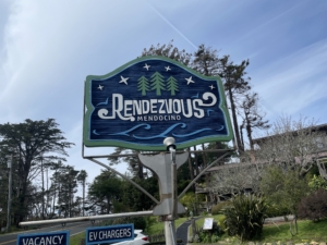
If you’re riding up to the legendary Lost Coast, make Rendezvous Mendocino your perfect overnight stop. We offer secure, convenient parking for your bike, comfortable rooms to recharge after a long day in the saddle, a relaxing hot tub to soothe those miles, and a hearty breakfast to fuel your next stretch of coastal curves. Plus, motorcycle riders receive 10% off weeknight stays.
- Address: 34591 S Hwy 1, Gualala, CA 95445
- Phone: (707) 510-1175
- Visit Website »


