Looking for an epic adventure, but don’t have the time to run a full BDR? Introducing Bite-Size Butler BDR maps brought to you by ADVMoto. A collection of the most primo slices of BDR – perfect for a weekend adventure.

Featured as pull-out center spreads in ADVMoto magazine

  • Epic sections of existing BDRs with the added feature of a loop
  • Mileage varies but all ridable in 1-2 days
  • Navigate BDR sections with the .gpx tracks & the loop with the map
  • Loops include scenic paved and dirt roads
  • Map legend includes food, fuel, and lodging options

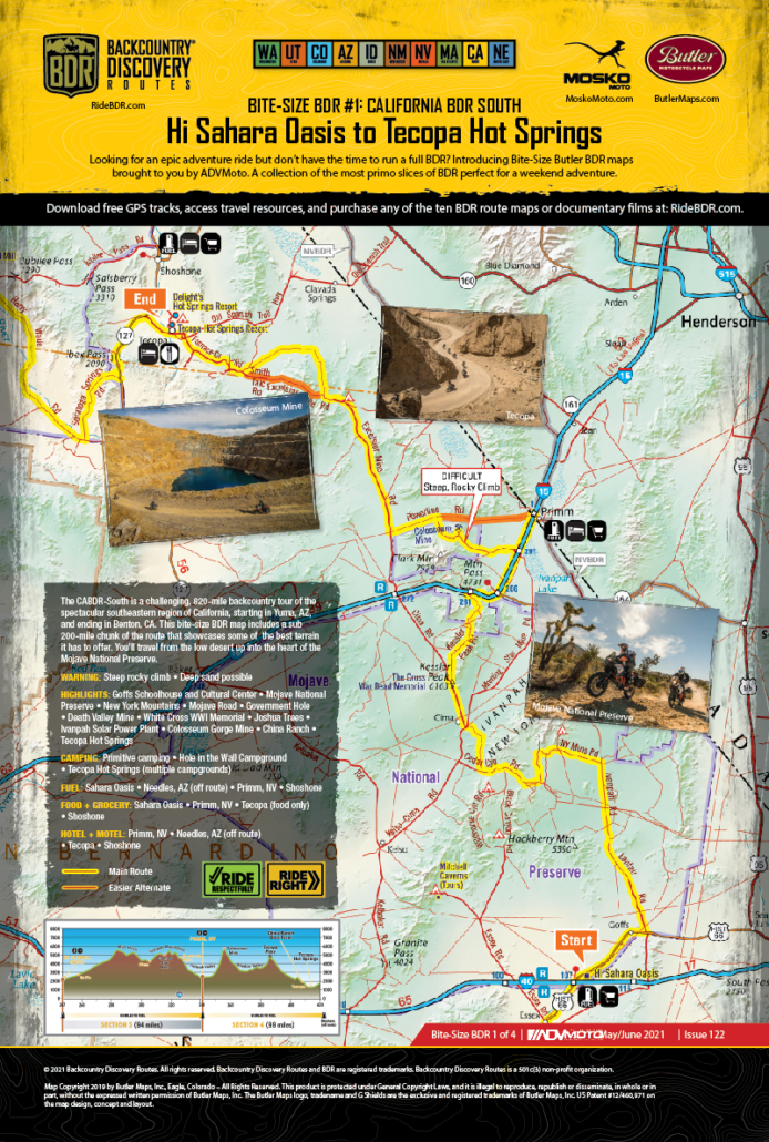
Hi Sahara Oasis to Tecopa Hot springs

The CABDR-South is a challenging, 820-mile backcountry tour of the spectacular southeastern region of California, starting in Yuma, AZ, and ending in Benton, CA. This bite-size BDR map includes a sub 200-mile chunk of the route that showcases some of the best terrain it has to offer. You’ll travel from the low desert up into the heart of the Mojave National Preserve.

WARNING: Steep rocky climb • Deep sand possible

HIGHLIGHTS: Goffs Schoolhouse and Cultural Center • Mojave National Preserve • New York Mountains • Mojave Road • Government Hole • Death Valley Mine • White Cross WWI Memorial • Joshua Trees • Ivanpah Solar Power Plant • Colosseum Gorge Mine • China Ranch • Tecopa Hot Springs

CAMPING: Primitive camping • Hole in the Wall Campground • Tecopa Hot Springs (multiple campgrounds)

FUEL: Sahara Oasis • Needles, AZ (off route) • Primm, NV • Shoshone

FOOD + GROCERY: Sahara Oasis • Primm, NV • Tecopa (food only) • Shoshone

HOTEL + MOTEL: Primm, NV • Needles, AZ (off route) • Tecopa • Shoshone

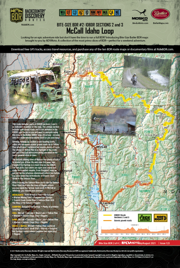
McCall Idaho Loop

This route includes parts of IDBDR sections 2 and 3 as indicated in yellow on the map. The orange section includes epic paved roads and is not included in the IDBDR .gpx tracks so you will need to navigate using this map or the Butler IDBDR map. It’s a loop – so jump onto this route wherever works best for you and enjoy!

Starting midway up Section 2 and heading north, riders will encounter scenic gravel roads up to Yellow Pine which aren’t technical but require plenty of focus. The village of Yellow Pine is a highlight of the route and you’ll find just about everything you need at the rustic general store in town.

The historic mining town of Warren has plenty of relics to remind you of how life was over 150 years ago. Burgdorf Hot Springs is a must stop on the IDBDR. The hot pools and cabins are open year-round and make for a perfect respite. From Burgdorf, keep an eye out for the infamous abandoned school bus before you wind down the switchbacks of French Creek Grade to the Salmon River.

After crossing the Salmon River you’ll ride the Salmon River Road west into the town of Riggins where you can rejoin the tarmac back south to McCall or wherever you started your journey!

HIGHLIGHTS: Town of Yellow Pine • Elk Summit • Warren Mining Town • Burgdorf Hot Springs • French Creek Grade Road • Salmon River AKA The River of No Return • Riggins

CAMPING: Burgdorf Hot Springs • Plenty of primitive camping

FUEL: McCall • Cascade • Warm Lake • Yellow Pine • Warren • Secesh Stage Stop • Riggins

FOOD: McCall • Cascade • Warm Lake • Yellow Pine • Warren • Secesh Stage Stop • Riggins

HOTEL + MOTEL: McCall • Yellow Pine: rooms at general store and a small B&B • Warren • Burgdorf Hot Springs: rental cabins (requires two night stay) • Riggins

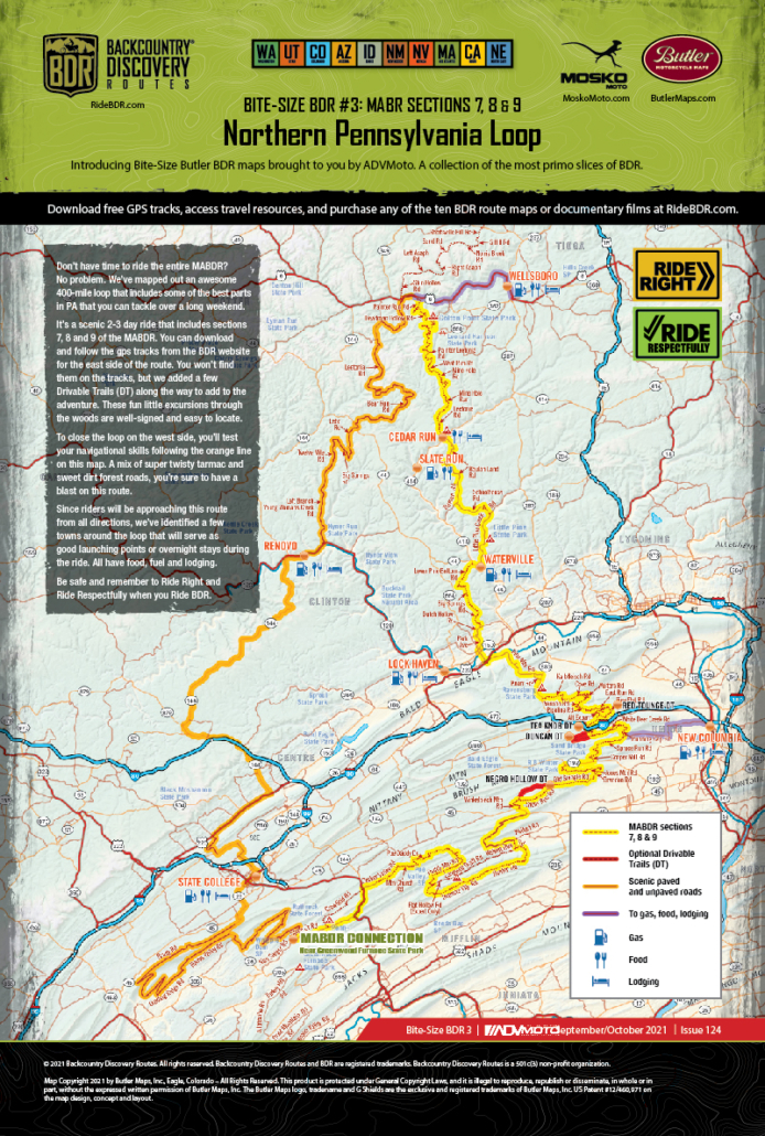
Northern Pennsylvania Loop

Don’t have time to ride the entire MABDR? No problem. We’ve mapped out an awesome 400-mile loop that includes some of the best parts in PA that you can tackle over a long weekend.

It’s a scenic 2-3 day ride that includes sections 7, 8 and 9 of the MABDR. You can download and follow the gps tracks from the BDR website for the east side of the route. You won’t find them on the tracks, but we added a few Drivable Trails (DT) along the way to add to the adventure. These fun little excursions through the woods are well-signed and easy to locate.

To close the loop on the west side, you’ll test your navigational skills following the orange line on this map. A mix of super twisty tarmac and sweet dirt forest roads, you’re sure to have a blast on this route.

Since riders will be approaching this route from all directions, we’ve identified a few towns around the loop that will serve as good launching points or overnight stays during the ride. All have food, fuel and lodging.

Be safe and remember to Ride Right, Ride Respectfully and Yield to Animals when you Ride BDR.

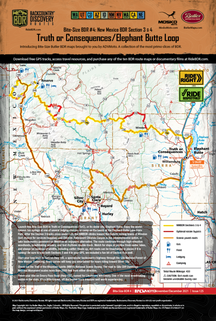
Truth or Consequences/Elephant Butte Loop

Launch this Bite-Size BDR in Truth or Consequences (TorC), or its sister city, Elephant Butte. Enjoy the worldfamous hot springs at one of several lodging choices, or camp on the beach at the Elephant Butte Lake State Park. After the Section 3 tracks cross under I-25, the NMBDR climbs toward the historic mining towns of Winston (last chance for services/supplies) and Chloride. Renowned Chloride Canyon is the adventuresome option, or take backcountry pavement on NM59 as an enjoyable alternative. The route continues through high-elevation woodlands, breathtaking scenery, and fast rhythmic double-track. Watch for stops at pristine fresh-water lakes, and always be cautious of wildlife, including cattle! Heads up, dirt roads can be treacherous in places if it is raining! Be sure to load both Sections 3 and 4 in your GPS, we included a fun bit of Section 4 as well.

Start your loop back to TorC on Hwy 180, a spectacular backcountry highway through the Gila National Forest of New Mexico. Sweeping, flowy curves will keep you entertained for hours riding toward Silver City.

Check out the Trail of the Mountain Spirits (NM15) National Scenic Byway. The road to Gila Cliff Dwellings National Monument scales more than 2000 feet from either direction.

Finish your ride on Emory Pass Road (Hwy 152), named for Lieutenant WH Emory. One of the most breathtaking routes in the state, it’s a little-known, off the beaten track treasure well worth experiencing.

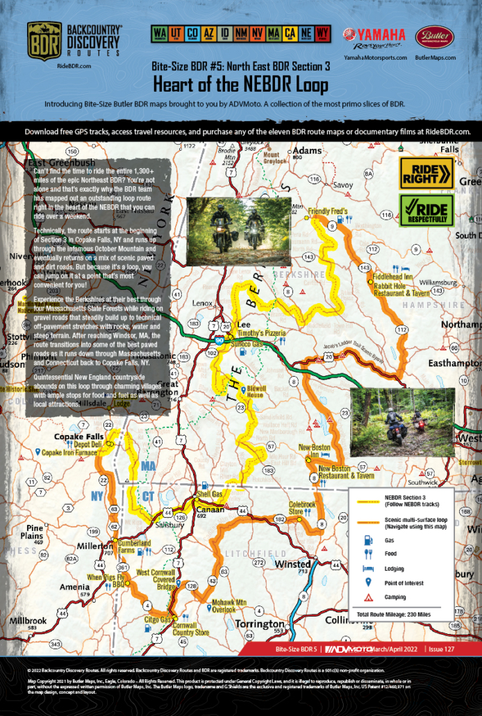
Heart of the NEBDR Loop

Can’t find the time to ride the entire 1,300+ miles of the epic Northeast BDR? You’re not alone and that’s exactly why the BDR team has mapped out an outstanding loop route right in the heart of the NEBDR that you can ride over a weekend.

Technically, the route starts at the beginning of Section 3 in Copake Falls, NY and runs up through the infamous October Mountain and eventually returns on a mix of scenic paved and dirt roads. But because it’s a loop, you can jump on it at a point that’s most convenient for you!

Experience the Berkshires at their best through four Massachusetts State Forests while riding on gravel roads that steadily build up to technical off-pavement stretches with rocks, water and steep terrain. After reaching Windsor, MA, the route transitions into some of the best paved roads as it runs down through Massachusetts and Connecticut back to Copake Falls, NY.

Quintessential New England countryside abounds on this loop through charming villages with ample stops for food and fuel as well as local attractions.

Slide Ridge Loop

Experience one of the highlights of the Washington BDR on this 80-mile loop that crosses Slide Ridge and the Chelan Mountains in Section 4 of the WABDR.

We suggest starting in the town of Entiat where you can gas up and purchase any provisions you’ll need for your ride. Running the loop clockwise is recommended and will begin with a scenic ride up the paved Entiat River Road. Soon after you’ll pass Cooper’s General Store in Ardenvoir and head north on NF-5300 and begin the ascent up into the Chelan Mountains. The road climbs to 6100 feet on the shoulder of Stormy Mountain on the crest of the range. From there you’ll traverse Slide Ridge on NF-8410 with incredible views of Lake Chelan. The road then descends on switchbacks to Twenty-Five Mile Creek State Park on the shore of Lake Chelan. The park has a campground as does Lake Chelan State Park down South Lakeshore Road. Your return to Entiat will take you south on Highway 971 and then Highway Alt-97.

From Seattle and the Puget Sound area, it’s about a three-hour ride via either Interstate 90 or Highway 2.

Alpine Loop

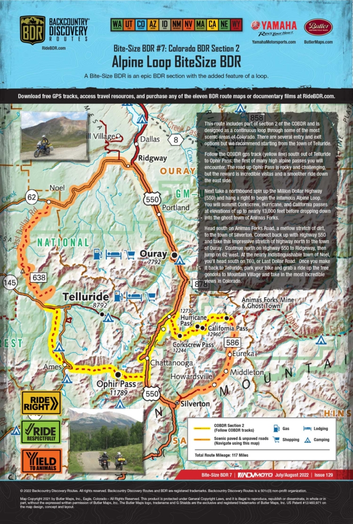
This route includes part of section 2 of the COBDR and is designed as a continuous loop through some of the most scenic areas of Colorado. There are several entry and exit options but we recommend starting from the town of Telluride.

Follow the COBDR gps track (yellow line) south out of Telluride to Ophir Pass, the first of many high alpine passes you will encounter. The road up Ophir Pass is rocky and challenging, but the reward is incredible vistas and a smoother ride down the east side.

Next take a northbound spin up the Million Dollar Highway (550) and hang a right to begin the infamous Alpine Loop. You will summit Corkscrew, Hurricane, and California passes at elevations of up to nearly 13,000 feet before dropping down into the ghost town of Animas Forks.

Head south on Animas Forks Road, a mellow stretch of dirt, to the town of Silverton. Connect back up with Highway 550 and take this impressive stretch of highway north to the town of Ouray. Continue north on Highway 550 to Ridgeway, then jump on 62 west. At the nearly indistinguishable town of Noel, you’ll head south on T60, or Last Dollar Road. Once you make it back to Telluride, park your bike and grab a ride up the free gondola to Mountain Village and take in the most incredible views in Colorado.

Moab Loop

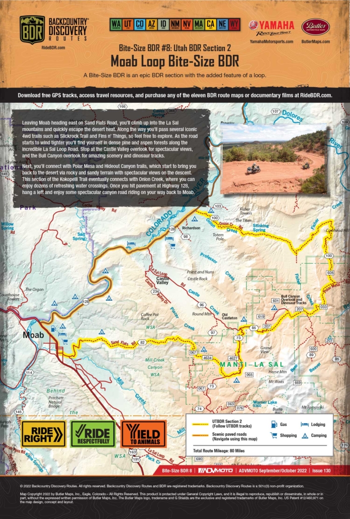
Leaving Moab heading east on Sand Flats Road, you’ll climb up into the La Sal mountains and quickly escape the desert heat. Along the way you’ll pass several iconic 4wd trails such as Slickrock Trail and Fins n’ Things, so feel free to explore. As the road starts to wind tighter you’ll find yourself in dense pine and aspen forests along the incredible La Sal Loop Road. Stop at the Castle Valley overlook for spectacular views, and the Bull Canyon overlook for amazing scenery and dinosaur tracks.

Next, you’ll connect with Polar Mesa and Hideout Canyon trails, which start to bring you back to the desert via rocky and sandy terrain with spectacular views on the descent. This section of the Kokopelli Trail eventually connects with Onion Creek, where you can enjoy dozens of refreshing water crossings. Once you hit pavement at Highway 128, hang a left and enjoy some spectacular canyon road riding on your way back to Moab.

Globe/Young Loop

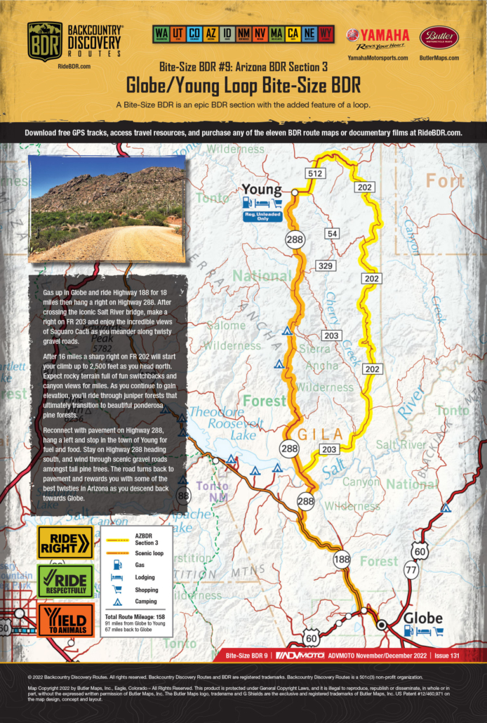
Gas up in Globe and ride Highway 188 for 18 miles then hang a right on Highway 288. After crossing the iconic Salt River bridge, make a right on FR 203 and enjoy the incredible views of Saguaro Cacti as you meander along twisty gravel roads.

After 16 miles a sharp right on FR 202 will start your climb up to 2,500 feet as you head north. Expect rocky terrain full of fun switchbacks and canyon views for miles. As you continue to gain elevation, you’ll ride through juniper forests that ultimately transition to beautiful ponderosa pine forests.

Reconnect with pavement on Highway 288, hang a left and stop in the town of Young for fuel and food. Stay on Highway 288 heading south, and wind through scenic gravel roads amongst tall pine trees. The road turns back to pavement and rewards you with some of the best twisties in Arizona as you descend back towards Globe.

Backcountry Discovery Routes is a 501c(3) non-profit corporation. © 2026 Backcountry Discovery Routes, Inc. All rights reserved. Terms of Use.